You can
sponsor
this page
Common name (e.g. trout)
contains
begins with
begins with
ends with
is
Genus + Species (e.g. Gadus morhua)
Über diese Seite
More Info
Plus d'info
Mais info
Sprachen
Arabic
Bahasa/Malay
Bangla
Chinese(Si)
Chinese(Tr)
Deutsch
English
Español
Farsi
Français
Greek
Hindi
Italiano
Japanese
Lao
Nederlands
Português(Br)
Português(Pt)
Russian
Swedish
Thai
Vietnamese
User feedbacks
Comments &
Corrections
Fisch Forum
Gästebuch
Facebook
Citation
Uploads
Webseite anhängen
Photo hochladen
Video hochladen
Upload
references
Fish Watcher
Verwandte Arten
Arten in
Conger
Arten in
Congridae
- Klassifizierung -
Congrinae
Congridae
Anguilliformes
Teleostei
Chordata
Animalia
Conger
oceanicus
(Mitchill
, 1818)
American conger
Beobachtung melden im
Fish Watcher
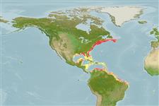
Native range
|
All suitable habitat
|
Point map
|
Year 2050
This map was computer-generated and has not yet been reviewed.
Conger oceanicus
AquaMaps
Data sources:
GBIF
OBIS
Hochladen
Photos
und
videos
Pictures
|
Google Bild
Conger oceanicus
Picture by
NOAA\NMFS\Mississippi Laboratory
Common names from other countries
Congre d'Amérique
,
Congrio americano
,
Dog eel
,
... more
Klassifizierung / Names
Namen
|
Synonyme
| Catalog of Fishes(
Gattung
,
Arten
) |
ITIS
|
CoL
|
WoRMS
|
Cloffa
>
Anguilliformes
(Eels and morays) >
Congridae
(Conger and garden eels) > Congrinae
Etymology:
Conger:
Latin, conger = conger (Ref.
45335
)
.
More on author:
Mitchill
.
Environment: milieu / climate zone / depth range / distribution range
Ökologie
seewasser
demersal; ozeanodrom (Ref.
51243
);
tiefenbereich
1 - 477 m (Ref.
5951
), usually 75 - 150 m (Ref.
5951
). Subtropical; 46°N - 16°S, 97°W - 5°W
Verbreitung
Länder
|
FAO Gebiete
|
Ecosystems
|
Vorkommen
|
Fatal error
: Uncaught mysqli_sql_exception: Table 'fbapp.scientificname' doesn't exist in /var/www/html/includes/speciessummary.lib.php:2055 Stack trace: #0 /var/www/html/includes/speciessummary.lib.php(2055): mysqli->query() #1 /var/www/html/country/CountrySpeciesSummary.php(1230): checkPointMApDisplay() #2 {main} thrown in
/var/www/html/includes/speciessummary.lib.php
on line
2055

")