The above section describes how FishBase uses WinMap. Developers of other databases with geographic components are welcome to use WinMap for their purposes; we consider it to be in the public domain. We would, however, appreciate an acknowledgment.
The MakeMap program was developed to assist the user in creating the command files needed by WinMap. You do not need MakeMap if you are displaying maps from inside FishBase. However, if you plan to use WinMap with another application, MakeMap will assist you in assembling and testing the WINMAP.LST file and the WINMAP.INI file.
Upon executing MakeMap, the form below will appear:
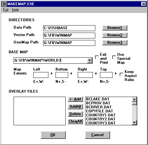
If the ‘OK’ button is clicked on, the selections will be saved. For the ‘DIRECTORIES’ section, the selections will be written to the WINMAP.INI file, while the selections for ‘BASE MAP’ and ‘OVERLAY’ will be written to the WINMAP.LST file.
The WINMAP.LST file is saved in the DataPath directory and the WINMAP.INI file is saved in C:\WINDOWS.
Click the arrow at the right of the Base Map field to see the list of available vector maps. The list of files that you can choose from includes those which are in the VectorPath and UserMapPath directories.
The ‘Exit & Print’ check box when selected will add an /X flag after the base map file. When WinMap is called, it will automatically create a black & white map according to the selections, copy that map to a TEMP.BMP file, and exit. The generated TEMP.BMP file is meant for printing and can be included into database reports and word processor documents.
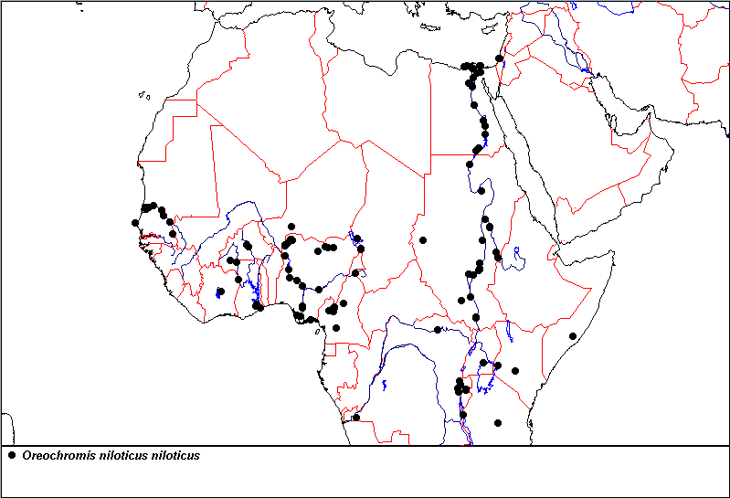
Fig. 61. Distribution map for Oreochromis niloticus niloticus as created with the ‘Exit & Print’ option. Note that WinMap was called and set to zoom in on northern Africa.
The ‘Use Special Map’ check box, on the other hand, adds an /S flag after the base map file. By default, WinMap uses three sets of world map, i.e., WORLD1._FL, WORLD2._FL and WORLD3._FL, with different levels of detail. The WORLD1._FL file has the highest level of detail. In most cases, WORLD3._FL is used to plot the initial world map. When a zoom operation is done, a world file is chosen depending on the size of the zoom area. Check this option if you want to zoom in on the WORLD3._FL or on a special ._FL file.
Different map extents can be indicated to overwrite the default map extents provided in the ._FR file and zoom in on an area (see the ‘WinMap Software’, this vol.). The ‘Keep Aspect Ratio’ check box will maintain the aspect ratio of the original map, even if new map extents are used.
For the overlay files, the list in the right window depends on the selected base map file. If the base map is in the VectorPath, the second column will list all DAT files from VectorPath and DataPath; and if it is in the UserMapPath, DAT files from UserMapPath and DataPath will be listed. Highlight a file in the right window and click on the Add button to add it to the selection of overlay files. See chapter on ‘The WinMap Software’ for more information on the various DAT files.
Note: Overlay files will be plotted in the same order as they are listed in WINMAP.LST.
We thank Edwin de Guzman for helping us with reading and saving BMP files in WinMap. We also thank Eliseo Garnace for helping us with the Windows help system and for other useful hints.
Coronado, G.U. and R. Froese. 1993. MAPPER, a low-level geographic information system. Naga, ICLARM Q. 16(4):43-45.
Coronado, G.U. and R. Froese. 1994. MAPPER, a low-level geographic information system. ICLARM Software 9, 23 p.
Lee, D.S., C.R. Gilbert, C.H. Hocutt, R.E. Jenkins, D.E. McAllister and J.R. Stauffer, Jr. 1980. Atlas of North American freshwater fishes. North Carolina Biological Survey, 1980-12, 868 p.
Grace Coronado and Rainer Froese